Consumer Electronics Show 2014 – Die besten Technologien fürs Spielen, Kommunizieren und Fliegen
Paris, 07.Januar 2014. Parrot, Spezialist für kabellose Geräte rund um Smartphones und Tablets, präsentiert auf der CES Innovationen, die 2014 verfügbar sein werden.
Durch die Expertise von Parrot bei kabellosen und signalverarbeitenden Technologien überzeugen auch die neusten, jetzt vorgestellten Projekte und Entwicklungen durch Kreativität und technologische Leistung in den drei Geschäftsbereichen des Unternehmens:
- Consumer Electronics mit einem starken Eintritt in die Welt der vernetzten Spielzeuge;
- Automotive mit der Demonstration einer innovativen und skalierbaren vernetzten Infotainment-Lösung – entworfen für Autohersteller;
- Drohnen mit großen technischen Neuerungen, insbesondere im professionellen Sektor.
Consumer Electronics
- Parrot MiniDrone: Eine Miniaturdrone, gesteuert mit einem Smartphone oder Tablet über Bluetooth Low Energy, die fliegt und vom Boden bis zur Decke rollt.
- Parrot Jumping Sumo: Das erste Roboterinsekt, gelenkt mit einem Smartphone oder Tablet im 5GHz WLAN, das bis zu 80 cm springt und 90 Grad-Drehungen vollführt.
Vernetztes Auto
- Parrot OEM: SOCA ist eine skalierbare, vernetzte Multimedia-Lösung, basierend auf Android und entworfen für Autohersteller (OEM).
Professionelle zivile Drohnen
- Parrot senseFly: Die Möglichkeit, während des Flugs ‘schiefe’ Luftbilder aufzunehmen, um noch umfangreichere Karten zu generieren.
- Pix4D: Ein neues Software-Paket mit einem bahnbrechenden Editierwerkzeug & Abonnementmodell.
Um den Parrot News zu folgen: www.parrot.com oder
Für weitere Informationen kontaktieren Sie bitte:
PARROT
Fabien Laxague – Vanessa Loury
Fabien.laxague@parrot.com / Vanessa.loury@parrot.com
Tel. +33 (0)1 48 03 89 83 / 60 58
Tel. +33 (0)6 80 90 97 59 / 06 86 56 81 33
Anja Wiebensohn – Christian Schindler
parrot@markengold.de
Tel. +49 (0)30 219 159 60
ÜBER PARROT
1994 von Henri Seydoux gegründet, entwirft, entwickelt und vertreibt Parrot fortschrittliche Technologieprodukte für Endverbraucher rund um Smartphones und Tablets. Parrot bietet das größte Portfolio an Freisprechkommunikationssystemen im Automobilmarkt. Parrot positioniert sich mit seinem weltweit anerkannten Know-how in den Bereichen mobile Konnektivität und Multimedia für Smartphones als einer der wichtigsten Akteure im In-Car-Infotainment Segment.
Darüber hinaus designt Parrot kabellose High-End-Multimediaprodukte im Bereich Audio und erforscht neue Möglichkeiten mit Bluetooth Smart-Technologien. Mit der Parrot AR.Drone, dem ersten Quadcopter, der via WLAN gesteuert wird und Augmented Reality nutzt, expandiert Parrot im UAV-Markt und bietet zudem für diesen weitere neue Lösungen für den professionellen Gebrauch an.
Der Hauptsitz von Parrot befindet sich in Paris, Frankreich. Parrot zählt heute weltweit 850 Mitarbeiter und realisiert den Großteil seines Absatzes im Ausland. Parrot ist seit 2006 an der NYSE Euronext Paris gelistet. (FR0004038263 – PARRO)
Weitere Informationen unter www.parrot.com
Parrot MiniDrone & Parrot Jumping Sumo
Wenn Technologie Spielzeuge erobert
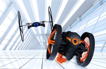
Mit der Parrot MiniDrone und dem Parrot Jumping Sumo, zwei hochtechnologischen, einfach zu nutzenden Spielzeugen, erfindet Parrot den Spielspaß für Kinder jeden Alters neu.
Parrot MiniDrone: fliegt und rollt vom Boden bis zur Decke!
Verbunden mit einem Smartphone oder Tablet über Bluetooth Smart (Low Energy), bietet die Parrot MiniDrone eine ähnliche Flugstabilität wie professionelle Drohnen.
Dank der zahlreichen Sensoren und des Autopiloten ist die Parrot MiniDrone der am einfachsten zu fliegende Quadrocopter.
Das ultrakompakte und leichtgewichtige Design kombiniert mit der Kraft der Motoren ermöglicht es der Parrot MiniDrone, mit hoher Geschwindigkeit zu fliegen und Akrobatik in bester Präzision zu vollführen.
Zwei Kohlefaserräder an der Minidrone befestigt und schon kann sie an einer Wand empor klettern oder sich an der Decke entlang bewegen – bevor sie wieder zu einem Flug startet.
Parrot Jumping Sumo: das ‘insektoide’ Spielzeug…
Der Parrot Jumping Sumo ist ein vernetzter Roboter eines neuen Genres, der sich mit einem Smartphone oder Tablet im 2,4 oder 5 GHz WLAN-Netz steuern lässt. Halb Roboter, halb Insekt, ist er mit einem Gyroskop und Beschleunigungssensor ausgestattet, die eine kinderleichte und intuitive Steuerung erlauben. Er rollt, dreht sich um 90 Grad – mit Schnelligkeit und erstaunlicher Präzision; kein Hindernis ist zu herausfordernd. Er vollführt spektakuläre Sprünge (bis zu 80 cm) und landet immer auf seinen Rädern.
Über die eingebaute Kamera werden seine Akrobatik und temporeichen Bewegungen auf das Display des steuernden Smartphones oder Tablets übertragen.
Projekte Parrot MiniDrone & Parrot Jumping Sumo
- Verfügbarkeit: 2014
- UVP: wird noch angekündigt
- Video auf http://youtu.be/3LZgTgI0REk
#parrot #ParrotJumpingSumo #ParrotMinidrone
Fortschrittliche Elektronik mit Android und Ethernet:
Parrot SOCA, eine skalierbare Infotainment-Architektur für Autohersteller
Mit Parrot SOCA bietet Parrot eine einmalige Vision eines vernetzten Autos mit einem modularen und flexiblen Infotainmentsystem, das auf Basis von Android 4.4 funktioniert – ohne Modifikationen des Quellcodes.
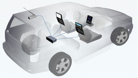
Beispiel der SOCA Architektur
In modernen Autos werden die Elektronik, die Displays und die Verbindungen zwischen den Systemteilen immer komplexer. Parrot erleichtert das Leben von Autoherstellern mit innovativen Technologien. Sowohl kabellos als auch über Ethernet lassen sich Geräte im Auto mit SOCA nutzen, das ein zuverlässiges Basissystem mit Android von Google darstellt.
Parrot SOCA ist die fortschrittlichste Implementierung von Android im Auto.
Damit können Autohersteller einfach folgende Features in ihre zukünftigen Modelle integrieren:
- Ein offenes System mit Steuerung über ein Touch- und Sprachinterface sowie ein komplett anpassbares Nutzerinterface, das auf die Automarke abgestimmt ist;
- Android Apps (Fahrassistenz, Navigation, Musik, Spiele etc.)
- Ethernet mit TCP/IP und Audio Video Bridging (AVB), die alle Inhalte und Video-Streams in Full HD, also 1080p übertragen – inklusive der Rückkameras. Das Resultat sind weniger Kabel, die das Gewicht des Autos reduzieren;
- Zugang zu den Informationen des On-Board-Computers;
- Bluetooth/WLAN/USB-Verbindung teilen oder über ein 4G-Modem;
- Freisprechtelefonie;
- · Erweiterte Fähigkeiten wie Miracast, um den Bildschirminhalt eines Smartphones zu spiegeln;
- Optional steht zukünftig die Parrot Smart Antenna zur Verfügung – eine Antenne, die Mittelwelle und UKW, Digitalradio und TV (DAB, TNT etc.) sowie GPS ins Auto bringt
Parrot SOCA ist skalierbar, weil es auf den aktuellsten Technologien und Protokollen sowie erprobten und kostengünstigen Hardware-Systemen basiert:
Für den Fahrerbildschirm und die Bildschirme in den Kopfstützen für die Passagiere können Autohersteller einfach Systeme installieren, die ähnlich wie berührungsempfindliche Tablets funktionieren und auf einem Prozessor wie Nvidia oder Parrot P7 basieren.
- Die Parrot SOCA Architektur funktioniert über eine 1-DIN Linux Box, die einfach zu integrieren ist und auf einem Dual Core Parrot P7 Prozessor aufbaut.
Dank der Parrot SOCA profitieren Autohersteller von einer umfassenden und skalierbaren Konnektivitätslösung zu moderaten Kosten.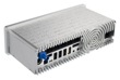
Parrot Smart Antenna
Die Architektur des Parrot SOCA kann mit der “Smart Antenna”, ein SDR (Software-Defined Radio), erweitert werden.
Sie ermöglicht das Management einer großen Anzahl an Signalen:
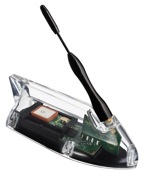
- MW/UKW-Radio, Digitalradio (DAB, DRM, HD-Radio)
- Digital TV (DVB-T, ATSC, ISDB-T, CMMB, CTTB)
- GPS
Sie besteht aus einer Antenne und allen notwendigen Empfängern in einer Box. Daher bedarf es keiner Installation von zusätzlichen Kabeln zwischen der Antenne und den einzelnen Empfängern.
Die Smart Antenna verteilt Signale über das Ethernet-Netzwerk zu allen verbundenen Anschlussgeräten. Das ermöglicht die Bündelung aller Signale in einem Kabel anstelle von Einzelkabeln für jedes Signal.
Mit der Nutzung eines beweglichen polyvalenten Empfängers und des Ethernet-Netzwerks ermöglicht die Parrot SOCA Architektur eine vereinfachte und kostengünstige Bereitstellung vielfältiger Signale für den Fahrer.
Parrot SOCA OEM Projekt:
- Verfügbarkeit: 2014
Parrot Smart Antenne:
- Verfügbarkeit: 2015
Parrot ist mit seiner OEM-Abteilung für Autohersteller mitführend im Bereich In-Car-Konnektivität. Bereits heute sind mehr als sechs Millionen Fahrzeuge mit der Highend-Technologie von Parrot ausgestattet.
Drone aerobatics, the creative solution for taking amazing oblique images
senseFly releases its patent-pending technology for oblique images, a truly innovative way to enable its fixed-wing mapping drones to take extraordinary images without the use of a gimbal.
senseFly’s drones eBee and swinglet CAM, both designed for mapping missions, are now also capable of quickly taking amazing oblique images to complement a mapping project or add additional documentation.
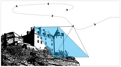
Figure 1 : orientation of the camera towards the photo target
This patent pending technology is based on a propriatary control algorithm that takes oblique images of photo targets without the need of a camera gimbal, enabling senseFly’s ultralight mapping drones to take aerial shots with up to 45° inclination from the photo target.
The algorithms running onboard the drone’s autopilot automatically place and orient the drone based on the defined image resolution and inclination (0-45°) selected by the operator. The drone then adapts its trajectory according to local wind and target altitude.
Having a system that positions the camera autonomously with respect to the photo target enables senseFly’s drone systems to take precise oblique images without the need for live video feedback or a camera gimbal.
As these new techniques do not require any hardware changes, this novelty is freely available to the full community of eBee and swinglet CAM (late 2012 model) users with the new release of eMotion 2.2.
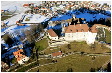
Figure 2 : image of the photo target
Beside creating stunning visuals, senseFly’s latest release of Postflight Terra 3D will enable users to go one step further and add these oblique images to a standard mapping flight, adding visibility to facades and vertical surfaces.
Watch the video here: senseFly’s patent pending oblique imagery
senseFly press contact: pr@sensefly.com
Telephone: +41 21 552 0466
For further information please visit: http://www.sensefly.com/about/news-press-room.html
About senseFly
senseFly is a Swiss company that develops and produces autonomous ultralight flying drones (also called UAVs) and related software solutions. The technology behind senseFly’s solution originated in 2001, when a team of robotic researchers at EPFL began investigating the control and navigation strategies of flying insects. This pioneering research enabled the development of a highly integrated autopilot employing smart control strategies similar to those found in flies and bees. senseFly was founded by a team of researchers, pilots and geomatic engineers in late 2009 and launched its first commercial product shortly after. The swinglet CAM is a flying drone for aerial imagery acquisition and mapping. In 2012 senseFly joined the Parrot Group and is since then more than ever pioneering the field of flying drones for mapping and GIS applications. Its latest product, the eBee, was launched in October 2012. The company currently employs more than 50 employees.
Pix4D releases new software package introducing ground-breaking editing tool
& subscription model
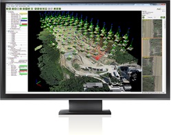
Pix4D announces the release of Pix4Dmapper, the new software package with a ground-breaking and fully integrated editing tool providing extended CAD and GIS possibilities. The rayCloud, Pix4D’s latest innovation included in Pix4Dmapper, combines the 3D point cloud with the original images for easy viewing as well as highly accurate semantic annotation and project improvement.
Pix4Dmapper is available as of January 13, 2014, both as a one-time charge license and a monthly or yearly subscription model to give customers all options without any limitations in a package that scales to all needs.
Pix4D’s goal is to provide customers with cutting-edge technology and ground-breaking tools combining the latest innovations of Computer Vision and Photogrammetry. Orthomosaics, DSMs and Point clouds generated with Pix4Dmapper achieve survey-grade accuracy from any aerial or oblique imagery, ranging from lightweight compact cameras used on UAVs (including GoPro, multi-spectral cameras and Fisheye lens) to SLR’s and large photogrammetric sensors carried by aircraft. New algorithms allow for even more precise and stunning results and help customers to get the most out of their UAV imagery.
While Pix4Dmapper’s fully automatic workflow stays as intuitive and easy to use as prior Pix4D software packages, it gives users full control over all tie points, calibration and results. Using the rayCloud Editor, users can now assess, edit, interpret and improve results directly in the software thanks to the rays connection the 3D point cloud to the original input images. The rayCloud makes it possible to annotate and measure objects with the highest accuracy, to fully control tie points as well as calibration and even to use annotations to reprocess projects in order to improve the overall project accuracy.
To help users get the most out of its ground-breaking technology, Pix4D has invested in creating an extensive Knowledge Base that is constantly updated with latest articles, advice and tutorials. Supporting customers in all project stages is key to Pix4D, reason why both Personal Support as well as free access to the Knowledge base are included in the first year of Pix4Dmapper.
Pix4Dmapper is an integrated solution tailored to needs of industries such as Mining, Topography, Agriculture, Construction, Natural Resources Management and more. Output results can seamlessly be imported into any GIS and CAD software packages. True to its spirit of continuous innovations, Pix4Dmapper already includes industry-specific developments for both the Mining and Agriculture market that will be extended over the coming months.
Details of Pix4Dmapper and video as well as tutorial of the rayCloud are available at www.pix4d.com as of January 13, 2014. Pix4D’s extensive Knowledge base can be accessed at http://support.pix4d.com
About Pix4D
With over ten years of leading scientific research and founded in 2011, Pix4D has become the main provider and industry standard for professional unmanned aerial vehicle (UAV) processing software. Started as a spin-off of the EPFL (Ecole Polytechnique Fédérale de Lausanne) Computer Vision Lab in Switzerland, Pix4D is a dynamic and rapidly expanding company. The company has grown from three people in 2011 to six people in 2012 to twenty-five people today and has its offices at EPFL Innovation Park in Lausanne, Switzerland.
Pix4D is your solution to convert thousands of aerial
images taken by lightweight UAV or aircraft into georeferenced 2D orthomosaics and 3D surface models and point clouds. With its advanced automatic aerial triangulation based purely on image content and unique optimization techniques, Pix4D enables civilian drones to become the next-generation mapping and surveying tool delivering survey-grade accuracy. Pix4D software offers up to centimeter-grade, LiDAR-like 3D precision, features a fully automatic workflow and can be used by anyone as it is very intuitive and easy to use. Assess, edit and improve your projects directly in the software using the integrated editing tools and seamlessly import your results into any professional GIS, CAD and traditional photogrammetry software package.
Pix4D’s latest software package, Pix4Dmapper, introduces the rayCloud, a ground-breaking concept of multi-ray photogrammetry. The rayCloud is combining the 3D point cloud with the original input images for easy viewing as well as highly accurate semantic annotation and project improvement.
For additional information as well as image material on Pix4Dmapper and the company, please contact Sonja Betschart at sonja@pix4d.com
Jumping Sumo, MiniDrone, Parrot, senseFly, Smart Antenna, SOCA