Parrot revolutionizes precision agriculture with Sequoia: a miniaturized high-tech multispectral sensor, compatible with all civil drones
Paris, February 8th. Crop management should evolve to become even more effective: it is necessary to know to better produce, improve its environmental performance, optimize its yield, save time, reduce expenses and thus develop ones farm.
 Few farms use multispectral imaging by drones or planes.
With its drones and Sequoia, Parrot makes this essential technology accessible to all.
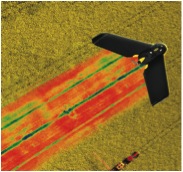
Sequoia is a multispectral mini-sensor capable of “measuring the invisible”: it takes calibrated pictures in the infrared and thus collects crucial data on crop growth.
With Sequoia, Parrot enables anyone in the farming world to access “big data”.
Revolution is not only to bring technological progress, but to make anyone taking advantage of it.
SEQUOIA – An accurate multispectral imaging solution
 Sequoia is a complete and accurate multispectral imagery solution for drones that captures images from crops in both visible and invisible spectrums.
Sequoia features:
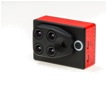
- A multispectral sensor that records images of crops in four distinct spectral bands: Green (500nm Bandwidth 40nm), Red (660nm Bandwidth 40nm), Red-Edge (735nm Bandwidth 10nm) and Near Infrared (790nm Bandwidth 40nm).
- A sensor equipped with a RGB camera (16 MP).
- A 64GB built-in memory.
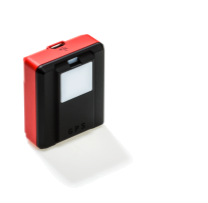
- A separate luminosity sensor (‘sunshine’ sensor) that records lighting conditions and automatically calibrates the four multispectral sensors. The ‘sunshine’ sensor offers an SD card slot for additional storage capability.
- Sequoia also embeds GPS and
With Sequoia, farmers can:
- Identify areas in a field that require special attention.
- Refine fertilization by detecting nutrient deficiencies.
- Optimize pesticide input by preventing and detecting biotic stresses (caused by living organisms).
- Control irrigation of crops by identifying variations of hydric stress threats.
- Estimate crop yield by processing and utilizing agronomic indexes.
SEQUOIA – A high-end solution designed for all UAVs
Covering hundreds of acres in one flight, drones make it possible to obtain extremely precise crop images.
“We have developed Sequoia with the goal of offering the agricultural world an accurate multispectral solution that is technologically advanced and compatible with fixed wing and multirotor drones available on the market,” explains Henri Seydoux, founder and CEO of Parrot.
With sensors the size of a GoPro, Sequoia is the first solution developed on an industrial scale that adapts to any type of civil drone.
- Fixed wings cover large acreage.
eBee from senseFly is the only fully automatic fixed wing drone and is already widely used in the agricultural world. With Sequoia onboard eBee, operators can cover hundreds of acres with a GSD of down to 2 cm per pixel.
“We are delighted to bring Sequoia’s cutting-edge multispectral performance to our professional eBee Ag drone,” said Jean-Christophe Zufferey, CEO and co-founder of senseFly. “The fact that this camera is immediately compatible with our eBee means operators can use these technologies to scout larger areas, effectively.”
- Multirotors cover smaller areas, make stationary flights at low altitudes and enable the capture of higher resolution images.
„Via the Drone Code Foundation, 3DR and Parrot have been able to collaborate in providing an end-to-end customer experience for the Parrot Sequoia sensor and 3DR’s enterprise drones and cloud solutions,” said Keith Bigelow, VP of Enterprise Division, 3DRobotics.
Precision agriculture, a priority market for Parrot
Sequoia is the first professional solution dedicated to agricultural technologies developed by Parrot and results from the group’s diverse expertise.
Parrot’s external growth strategy focuses on ownership interests in leading companies in the commercial drone market, specifically precision agriculture.
The ramp-up of the group on this market specifically translated to the acquisition of professional drone specialist senseFly in 2012, aerial cartography specialist Pix4D in 2013 and majority investments in data processing and agronomic specialists MicaSense and Airinov in 2015.
The Parrot Group has a leading position on the civil drone market and it intends to become a major player in precision agriculture by combining advanced software solutions and sensors adapted to different crop types.
Cartography, data processing and agronomic analysis of data from Sequoia
Desktop processing software
- Thanks to Pix4Dmapper Pro software, data recorded by Sequoia is converted into orthomosaics and maps according to different vegetation indexes, including NDVI (Normalized Difference Vegetation Index).
These maps provide information on the health of crops, which crop consultants can transform into recommendations (fertilizer, pesticides, and irrigation).
As a clear move towards the agricultural market, Pix4D launches Pix4Dmapper AG, a dedicated version of its software which will be available with Sequoia.
Cloub-based data solution
- MicaSense offers ATLAS, a cloud-based processing and analytics platform for data captured with Sequoia. Data is processed into accurate and powerful crop health maps that can be accessed from any connected device for use in the field.
Offering calibrated outputs and unlimited data storage for in-season and season-to-season analysis, ATLAS is an intuitive and powerful solution for agricultural professionals.
Agronomic analysis of data
- Airinov offers measure and recommendation service. The raw data captured by Sequoia are converted into maps with a precision of 1m² in the form of agronomic indexes, in absolute scale and adjusted scale (Nitrogen absorbed, dry biomass).
Thanks to analytic software developed with INRA (French National Institute of Agricultural Research) and Terres Inovia (Interprofessional Technical Center for Oilseed Crops), Airinov team can provide the farmer with recommendations (in unit per hectare) for fertilization of wheat (3 & 4) and rape (total dose). For the other crops and countries where Airinov services are in deployment, zoning of projected doses already enable to enter precision agriculture.
Provided in two formats for manual or automatic modulation, these recommendations are crucial for the farmer: fertilizer is a primary expense; the environmental consequences of fertilizer waste are well known; and the spreading is strictly regulated in many countries.
***
Sequoia will be released in March 2016 for the MSRP $3,500 USD.
To learn more about Sequoia, please visit www.parrot.com/sequoia or meet Parrot and its partners at the following industry events:
- February 9-11, 2016 : World AG Expo, Tulare, California, USA
- February 27 to March 6, 2016: Salon de l’Agriculture, Paris, France.
***
Press contacts
PARROT
Fabien Laxague – Vanessa Loury
fabien.laxague@parrot.com / vanessa.loury@parrot.com
Tel. +33 (0)1 48 03 89 83 / +33 (0)6 80 90 97 59
Tel. +33 (0)1 48 03 60 58 / +33 (0)6 86 56 81 33
ABOUT PARROT
Founded in 1994 by Henri Seydoux, Parrot creates, develops and markets advanced technology wireless products for consumers and professionals.
The company builds on a common technological expertise to innovate and develop in three primary markets:
- Civil drones: With recreational quadricopters and solutions for professional use.
- Connected objects: With a focus on audio and gardening.
- Automotive: With the most extensive range of hands-free communication and infotainment systems for vehicles on the market.
Headquartered in Paris, Parrot currently employs more than 900 people worldwide and generates the majority of its sales overseas. Parrot has been listed on Euronext Paris since 2006. (FR0004038263 – PARRO)